
| ABOUT | ARTICLES | FORUM | RESOURCES | GALLERY | CROSS |
|
|
|
|||||||||||||
|
||||||||||||||
|
Talk about this article... The Powell Survey of the 1870s: Art & Science from the Saddle January 23, 2009 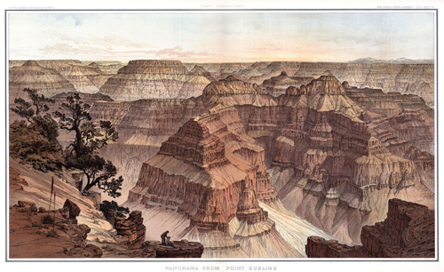 Point Sublime by William Henry Holmes The most excellent professional papers produced by the Powell Survey (1871 to 1879), and formally called the United States Geographical and Geological Survey of the Rocky Mountain Region, were accomplished more from land-based expeditions, than the famous river expeditions of 1869 and 1871. The professional papers of the Powell Survey are:
The artwork of the Powell Survey are:
The women of science in the Colorado River Basin
Anthology of John Wesley Powell
NARRATIVE John Strong Newberry (1822-1892) was the most influential mentor of the individuals who became the Powell Survey. Eleven years before Powell completed his river trip, Newberry had already explored the lowermost section of the Colorado River by steamboat, and then by horseback surveyed roughly the bottom of the Grand Canyon at Diamond Creek. Later, Newberry observed the ruins of the Ancestral Puebloans near Mesa Verde and reached, by horseback and probably within a few miles, the Confluence in Canyonlands (the junction of the Green and Colorado rivers); all three areas are now national parks.
Newberry was a charter member of the National Academy of Sciences. He used his influence with Congress to secure funding for the Powell Survey. Newberry's influence also convinced Congress to consolidate the four national surveys into one entity, the United States Geological Survey (USGS), of which Powell served as it's second director. As director of the Ohio Survey, Newberry personally mentored Grove K. Gilbert, who became America's great engine of scientific research . Both Newberry and Gilbert have written professional papers on the igneous intrusive mountains of the Colorado Plateau--the Abajos and the Henry's, respectively.
John Wesley Powell (1834-1902). Without a doubt, no man of the 19th century knew the Colorado Plateau better than Powell. The first chapter in Exploration of the Colorado River of the West testifies to this fact. The Colorado Plateau geophysical province is divided into six sections, all traveled by Powell on the saddle: the Uinta Basin, Canyonlands, High Plateaus, Grand Canyon, Navajo, and Datil. See Cenozoic Geology of the Colorado Plateau by Charles Hunt (1956). Powell also had an intimate knowledge of the Colorado River through the geophysical provinces of the Rocky Mountains and the Basin and Range. Generally, in his prepared talks or testimony, Powell framed the river's big picture with his audience via the watershed approach.
Grove K. Gilbert (1843-1918). Gilbert defected from the survey of Lt. George Wheeler upon Powell's invitation to attend his. Gilbert was with Wheeler in the autumn of 1871 when that survey rowed/towed boats up the Colorado River to Diamond Creek in Western Grand Canyon, and then left the area by trail on horseback.
Gilbert did this because Powell sincerely intended to produce the highest quality science and literature without wasting time and money. Gilbert understood that this could not happen under Wheeler's direction. Edwin McKee, considered the father of Grand Canyon geology, viewed Grove K. Gilbert as America's greatest geologist. Few would argue this point: twice Gilbert served as the president of the Geological Society of America. Gilbert was Powell's first choice to serve as his successor in the USGS. The post went to Charles Walcott, another famous Grand Canyon geologist. Gilbert instead preferred to serve as chief geologist for the USGS, where he established the principles of nomenclature and cartography. His writings are masterpieces interpreting such subjects as igneous intrusive mountains (laccolith), Basin and Range extension, the glacial phenomenon, pluvial lakes (Lake Bonneville), the denudation of the Colorado Plateau, and debris flows. After the death of his wife Fannie (whom he met at a dance in Powell's home) he partnered with Alice Eastwood (whom he met on a Sierra Club excursion). Ms. Eastwood was a botanist who conducted research on the Colorado Plateau before meeting her husband.
Clarence E. Dutton (1841-1912); a biography. Powell borrowed Dutton from the U. S. Army where he served as an officer in the Ordinance Corps (weaponry). His specialty was chemistry and metallurgy, which prepared him for the assignments Powell gave him, namely, igneous extrusive structures (volcanism). Dutton worked on the igneous extrusive structures of western Grand Canyon, western New Mexico, Hawaii and the Cascades (Newberry actually preceeded Dutton in describing the extrusives of the Basin and Range and the Cascades). His monograph The Tertiary History of the Grand Canyon District (1882) is highly prized by modern-day book collectors. Dutton's geologic insight was impressive, but his ability as a nature writer was uncanny. Dr. Wallace Stegner did his graduate thesis on the literary work of Dutton and called him "the John Muir of the Colorado Plateau." Stegner's infamous book Beyond the Hundredth Meridian: John Wesley Powell and the Second Opening of the West is an outreach of that graduate work. Additional reading:
Talk about this article... |
| ||||
