| ABOUT | ARTICLES | FORUM | RESOURCES | GALLERY | CROSS |
|
|
|
|||||||||||||
|
||||||||||||||
|
Talk about this article... The Water Imbalance of the Colorado River Basin January 16, 2010
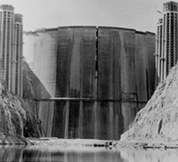
There is sufficient information available right now to make a simple determination that surplus water in the Colorado River basin does not exist anymore. It is also evident that cutbacks to the lower basin states will likely begin in early 2012, if the drying trend for Lake Mead continues. The consequence of massive fossil fuel consumption is a spoiled snowpack. Degrading the primary component of water wealth is why the system is in decline. The behavior of consumers indicates this will continue to be a problem for the rest of the century, if not longer. There is talk of restoring the balance, but it is background noise compared to the talk of completing traditional big water projects. Utah, for example, believes it has an entitlement to deplete another 361,500 acre-feet, and the state of Colorado another 700,000 acre-feet. An acre-foot of water is a football field, one foot deep (325,851 gallons). Some of this fantasy water may be dedicated to oil shale extraction to render low-grade oil and gas products that will only make the water scarcity situation even worse. Read: Why you should know about oil shale Stationarity Is Dead Nature is not fixed, but water managers make fixed assumptions nonetheless that trend towards the optimistic. It is a system with disappointment built into the matrix and the Colorado River is the finest example of illusionary accounting there is. Read: Stationarity is Dead: Whither Water Management One of the first hydrology studies that analyzed the gaging data to determine the annual water yield of the Colorado River at the Compact Point (Lee's Ferry, Arizona) was written by Raymond A. Hill in 1953 for the state of Colorado. The study's main result, which has prevailed 50-years hence, revealed that the average annual stream flow for the 20th century is 15 million acre-feet (maf), and not 17.5 maf as assumed by the founders of the 1922 Colorado River Compact. The subsequent studies after Hill, that arrived at the same basic yield (15 maf), include the report in 1965 by R. J. Tipton for the Upper Colorado River Commission, and the hydrologic determinations of 1988 and 2007 by the Bureau of Reclamation. This would also include the spreadsheet of Colorado River natural flow compiled by James Prairie of the Bureau of Reclamation, as revised in 2009. The problem with this accounting procedure is that the instrument record is only 110 years old, and the Colorado River drainage is 6 million years old. The river and its fauna have weathered ice ages and desertification before. Water developers used faulty and incomplete data and built the system accordingly. Unlike Nature, human engineering is not designed to work outside of assumed parameters, especially if they are wrong. So, of course, reservoir extremes will be exceeded in their lifetimes on both sides of the spectrum, namely big droughts and big floods. With luck they may survive these extremes but the engineering is, unfortunately, not as clever as Nature. It is now understood that the 20th century was the wettest century in the last ~1,200 years, according to tree-ring record. Statistically this means that the 21st century will be drier, which so far has proven to be true. In fact 30% drier, which means the real-time instrument record is more alarming than the tree-ring record of the past and climate change models of the future. The Declination of Colorado River Streamflow (view trendline) A significant peer-reviewed document was issued in June of 2009 by scientists from the University of Colorado at Boulder, the National Atmospheric and Oceanic Administration, and AMEC. Inc. Balaji Rajagopalan was the lead author. This paper was a component of a project of the Western Water Assessment called: Reconciling Projections of Future Colorado River Streamflow. The document indicates that under the current interim guidelines, the management of the Colorado River's system of reservoirs will remain robust and flexible until 2026. However, for the subsequent decades to 2057, water managers will need to find solutions to mitigate an annual system loss of 3 million acre-feet, or 20%, and as a consequence of persistent drying caused by greenhouse gas emissions. The authors of this report have also looked at the present conditions of supply and demand. For example, Kenneth Nowak presented a water budget of the basin based on the 15 maf annual yield for the Colorado River. The budget (graphic) indicates what remains in the system right now for depletion is a mere 400,000 acre-feet. This is the amount of water that Nevada uses every year. If Nowak had created this water budget based on the annual yield according to the tree-ring record of the last 1,200 years, there would be only 100,000 acre-feet remaining in the system for depletion. This yield is derived from the most conservative of tree-ring studies, namely 14.7 maf. Furthermore, if Nowak had created this water budget based on the estimate that climate change has already depleted the Colorado River by 6%, or 900,000 acre-feet, then water managers need to find ways to put 1/2 million acre-feet back into the system right now to balance the water budget. This amount may be conservative as well, since the reservoir elevation at Lake Mead is fast-approaching the designated first tier where water diets begin for the states of Nevada and Arizona. (current elevation @ Lake Mead) (@ Lake Powell). If Lake Mead recedes to elevation 1025, a reconsultation of the current management plan (Shortage Criteria) would begin (see 2007 ROD). This indicates that the water managers would not entirely drain the reservoir. However, for Lake Powell there is no set elevation tier that would trigger reconsultation, which begs the question: just how far will the managers let Lake Powell drop in elevation? With subsequent reservoir lowering Arizona goes into a situation of forced dehydration and Phoenix becomes an irony to the mythological bird it is named after. From here on out, it is not going to be easy and it is going to get very expensive and litigious. But what is really telling in this basin is the obsessive behavior it has to develop the maximum supply of water to the last drop. Until this attitude changes, water security will never be. What can be done is to finally heed the advice of John Wesley Powell to be humble in our approaches to manage water in arid climates, rather than setting expectations that go beyond the service limits of the native watershed.
Additional information:
February 23 & 24, 2010 Water SMART Kick Off Workshop SECURE Water Act Deliverables
Talk about this article... |
| ||||